AI Checker
Plagiarism Checker
Grammar Checker
Content Quality
Guideline Checker
Readability Checker
Fact Checker

Chrome Extension

Pinterest has become one of the most popular starting points for planning an outdoor trip in Canada.
Whether someone is mapping out their first visit to Banff, planning a multi-day backpack on the West Coast Trail, or researching a day hike in Kananaskis, hiking guides shared on Pinterest are often among the first resources they seek out before packing a bag.
The concern is that probable AI content has made its way into the travel blog ecosystem just as it has in recipes for medical diets and U.S. hiking guides.
An AI model writing something like a "complete guide to hiking in Jasper" may not know which trails were closed after a wildfire, whether a route requires a permit booked months in advance, or that wildlife activity has temporarily closed a corridor that was open last year.
For hikers heading into Canada's backcountry, some of the most remote and demanding wilderness terrain in the world, relying on probable AI-generated information can be genuinely dangerous.
Outside of Pinterest, the concern around AI-hiking content is already well-documented in Canada.
In 2025, Sandra Riches, executive director of BC AdventureSmart, told Canada's National Observer that when hikers blindly trust AI-generated routes without cross-referencing official sources, "they have that risk of getting lost or putting themselves in unsafe situations."
When the BC Adventure Smart team reviewed the reasons behind the 1,960 SAR (search and rescue) activities in BC in 2024, they saw a significant rise in AI-related incidents.
So, at Originality.ai, we set out to measure how widespread the problem of probable AI hiking guides is on Pinterest, specifically for Canadian destinations.
Using the same Playwright browser automation library developed for our medical diet Pinterest study and U.S. hiking guide study, we analyzed 1,000 hiking guide URLs from Pinterest searches across 40 Canadian national parks, provincial parks, and backcountry trail keywords, then ran each through the Originality.ai detection API.

Of the 1,000 URLs scored, 106 (10.6%) were classified as Likely AI.
That’s nearly 1 in 9 hiking guides surfaced on Pinterest to people actively planning trips across some of Canada's most visited national parks, provincial parks, and backcountry trails.
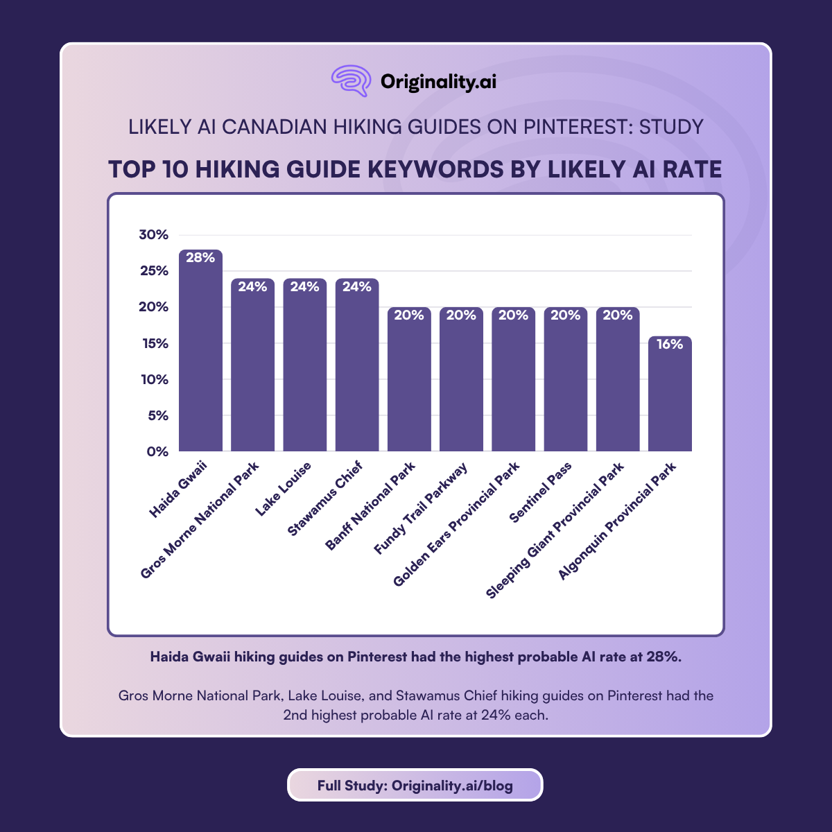
Haida Gwaii is a remote archipelago of more than 150 islands off the northwest coast of British Columbia, not a single park, but a region encompassing multiple protected areas, including Gwaii Haanas National Park Reserve and Haida Heritage Site, Naikoon Provincial Park, and several other ecological reserves.
For example, for Gwaii Haanas specifically, Parks Canada is unambiguous — there is no road access — visitors arrive by boat or seaplane only.
Advance reservation is required, along with a mandatory self-guided online orientation and proof of both (which visitors are advised to download ahead of time due to the lack of cell service) when travelling in the park.
Further, Parks Canada notes that, “Emergency responses are weather dependent, and thus in foul weather it may be many hours before emergency response personnel reach visitors in distress.” All boats that travel to Haida Gwaii must also have a VHF radio. There is no cell or internet service anywhere in the park reserve.
If a probable AI guide describes Haida Gwaii without accurately conveying these logistics, or if it compares Gwaii Haanas with the archipelago's more accessible provincial parks, it is setting visitors up to arrive underprepared at one of the most remote and logistically demanding wilderness areas in the country.
Three keywords tied at 24%, each with 6 of 25 guides flagged as being Likely AI.
Gros Morne National Park is a UNESCO World Heritage site on Newfoundland's west coast whose signature hike, the climb to the summit of Gros Morne Mountain, is one of the most demanding in eastern Canada.
Parks Canada is explicit that this hike is recommended for experienced hikers, with 1000 metres of elevation gain, which involves a 500m climb up a steep scree slope.
The full hike is 17 kilometres return, with a total estimated time of 6 to 8.5 hours at a minimum. The summit trail also has a mandatory seasonal closure from May 1 to June 27th, reopening June 28th each year, to protect wildlife.
Parks Canada warns visitors directly: "Don't be the ill-prepared or inexperienced hiker who puts themselves and others in danger and needs rescue."
One Likely AI guide listed inaccurate information about the Gros Morne Mountain Trail:
Further, the article describes the hike as being so popular that hikers will have “constant company.”
While hikers may encounter other hikers, the implication that hikers on the trail will have constant company doesn’t fully convey the remoteness of the location.
For instance, Parks Canada states that the hike is so remote that if emergency services are required, it could take hours for them to arrive, “Be prepared. Emergency assistance may take many hours to arrive due to weather, darkness or remoteness.”

Lake Louise is a popular photography destination in Canada, making it a natural target for probable AI content operations.
The area's trails range from what Parks Canada describes as ‘Easy,’ such as the lakeshore path (approx. 1 hour with minimal elevation changes), to routes requiring significant fitness and technical preparation, such as Sentinel Pass from Paradise Valley, described by Parks Canada as ‘Difficult’ (approx 9-10 hours with a 1,160m elevation gain). More on Sentinel pass below.
Stawamus Chief in Squamish is a popular hike in Southwestern BC. However, BC Parks notes that “Chief Trail is a steep and difficult climb,” and warns that “Rockfalls can occur at any time within the park.” Accurate route descriptions and difficulty ratings matter here, particularly for visitors who may be planning their first hike.
Five keywords tied at 20%, each with 5 of 25 guides flagged as Likely AI. Let’s take a closer look.
Banff National Park is Canada's most visited national park and a high-profile hiking destination, making it a popular keyword for probable AI content operations to target.
The park's permit systems, wildlife closures, and seasonal conditions are complex and change every year.
Parks Canada regularly issues wildlife advisories and temporary trail/area closures in response to wildlife (this can include bear activity).
Outdated or likely AI guides that describe trails without current wildlife information or closure status could send hikers into unsafe situations.
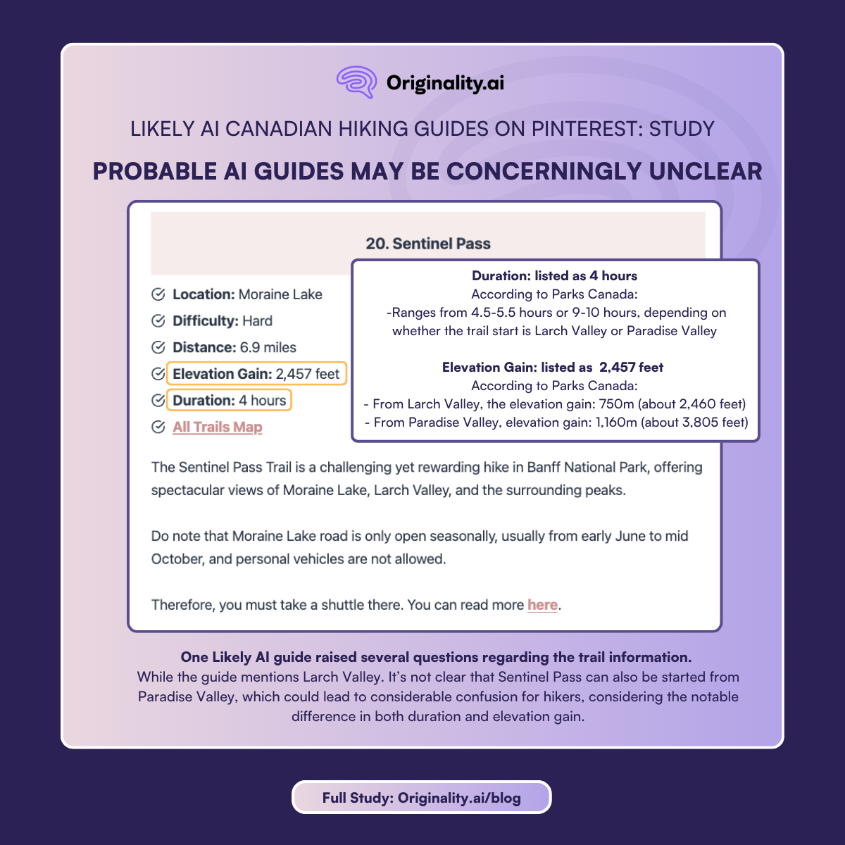
Sentinel Pass in Banff is considered a difficult hike, and can be completed from Paradise Valley or Larch Valley (located in the Lake Louise area).
Either way, the hike is listed by Parks Canada as a Difficult Trail. Accurate difficulty ratings matter for anyone planning it as a day hike.
One guide for Sentinel Pass that was flagged as Likely AI raised several questions regarding the trail information.
Duration: The probable AI guide listed the hike duration as 4 hours, which could be a dangerous inaccuracy for hikers who underestimate the time they need to complete the hike, considering it can range from 4.5-5.5 hours or 9-10 hours depending on whether the trail is started from Larch Valley or Paradise Valley.
Elevation Gain: Additionally, the elevation gain was also unclear. From Larch Valley, the elevation gain is 750m or about 2,460 feet. That’s close to the 2,457 feet listed. However, from Paradise Valley it’s substantially higher, as the elevation gain is 1,160m or approx. 3,805 feet.
While the guide does mention Larch Valley as a possible starting location, it’s not clear that Sentinel Pass can also be started from Paradise Valley, which could lead to considerable confusion for hikers, considering the notable difference in both duration and elevation gain.
Sleeping Giant Provincial Park sits on the Sibley Peninsula above Lake Superior in Ontario. According to Parks Ontario, it features the dramatic Top of the Giant trail with the tallest cliffs located in Ontario on a 21.8 -kilometre route, and is described as a difficult climb.
Its relative obscurity compared to Ontario's more famous parks means first-time visitors could be especially likely to trust whatever they find online without cross-referencing official sources.
Golden Ears Provincial Park in the Fraser Valley is one of BC’s most visited camping destinations, according to BC Parks. Its backcountry trails, particularly the Golden Ears summit route, are significantly more demanding than the park's lower trails would suggest to a casual visitor.
The summit climb (listed under ‘climbing’) to the Golden Ears Peak begins with a 12-kilometre trail, one way, with a 1,500m elevation change. BC Parks further notes, “The round trip is an overnight expedition for all but the fittest.”
BC Parks also notes that cell phone service may have poor reception or not at all in certain areas of the park.
Probable AI guides that describe the park without distinguishing between the lower trails and the summit route/climb, or that omit the remoteness of the park, could leave hikers significantly underprepared.
Fundy Trail Parkway in New Brunswick is a coastal hiking destination that requires hikers to be informed. Parks New Brunswick provides tide tables so that hikers and tourists can stay aware of the impact of tidal conditions.
Probable AI guides that may describe it without flagging tidal timing of the route are omitting information that is directly relevant to hiker safety.
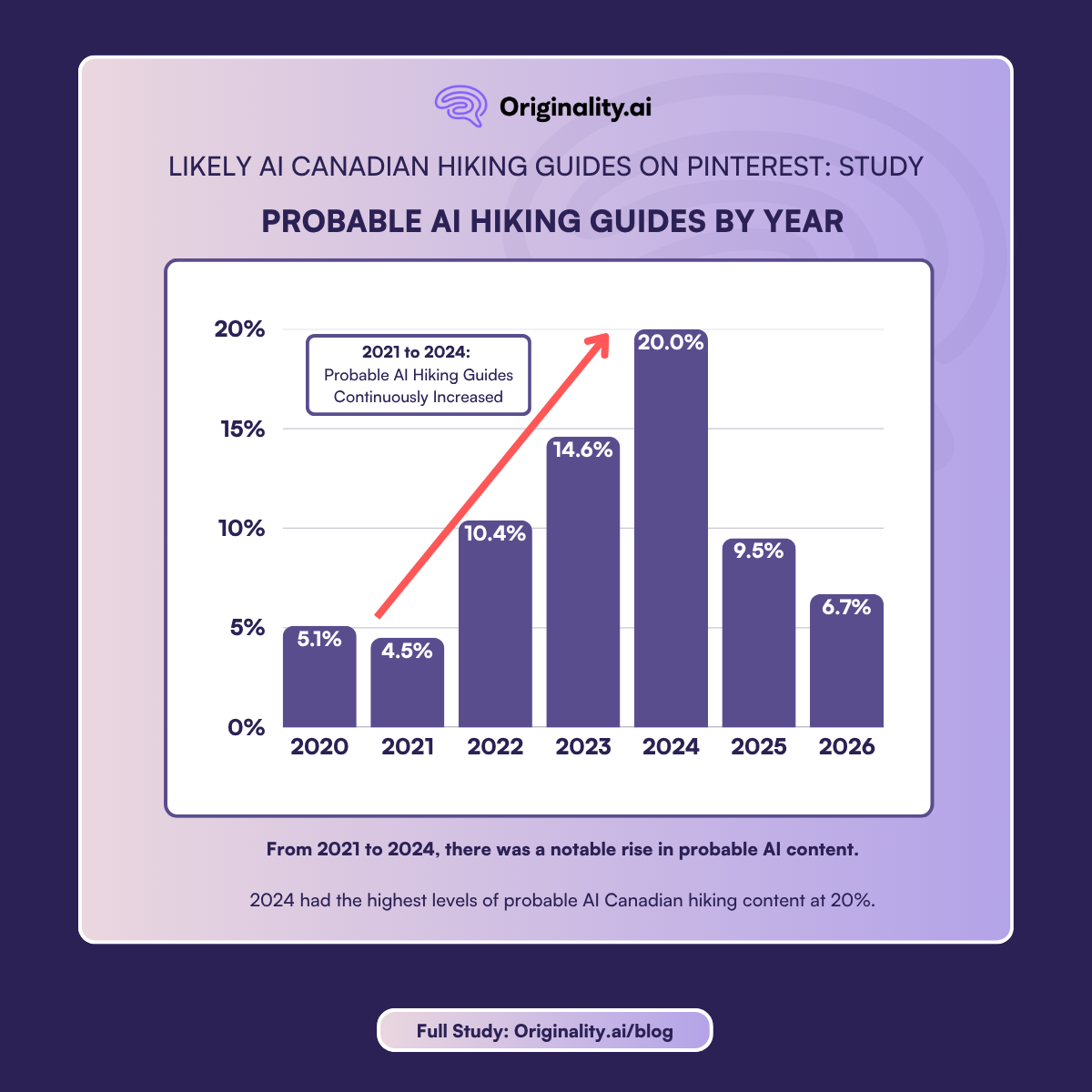
One of the clearest findings in this dataset is the relationship between publication year and AI detection rate.
That inflection point corresponds with the public launch of ChatGPT in November 2022.
The year-by-year breakdown (as shown in the chart above) makes the pattern clear. From 2021 to 2024, there was a notable rise in probable AI content.
2024, similar to the US hiking guides study, also saw the highest levels of probable AI Canadian hiking content at 20% (for US hiking guides, 2024 had 22% probable AI guides).
The 2025 figure of 9.5% and the partial 2026 count, at just 6.7% so far, suggest the trend has stabilised — but at an elevated baseline.
A Pattern Worth Noting: Repeat Likely AI Hiking Domains
Three domains had multiple guides flagged as Likely AI across several keywords.
This is a similar pattern to what Originality.ai has documented in prior research, for instance, in our study on medical diet content: a small number of operations publishing probable AI content at scale across some of the most-searched keywords.
Probable AI-generated content about Canadian backcountry hiking can be dangerous.
Canada's national and provincial parks span some of the largest and most remote wilderness terrain on earth. Cell service is limited or absent across many backcountry routes.
Weather changes rapidly at elevation and off large bodies of water. Wildlife encounters, bears, cougars, moose, are not hypothetical.
Trail conditions vary dramatically by season, and many popular routes are not maintained in winter or early spring.
In December 2024, North Shore Rescue in BC warned the public after two visitors became stranded in separate incidents just days apart.
Both had relied on hiking apps to plan their routes, with one hiker described as having "seriously underestimated the difficulty" of a route marked in an online app.
In another case, two hikers used ChatGPT and Google Maps to plan a route up Unnecessary Mountain near Vancouver, arriving in flat-soled shoes with no idea the peaks still had snow.
Lions Bay Search and Rescue had to climb up with boots and ski poles to extract them. "This call was a good reminder that AI tools like ChatGPT and Google Maps are not always the best for backcountry navigation," the team said, as quoted in the Whistler Daily Post.
There are two distinct weaknesses with AI-generated hiking content.
The first is factual inaccuracy: wrong trail distances, outdated permit systems, missing seasonal warnings, or no mention of wildlife closures.
The second is false confidence. An AI guide that does not know current conditions at a trailhead will not flag its own uncertainty. It will generate an authoritative-sounding paragraph that reads exactly like a guide written by someone who has been there.
Pinterest's algorithm surfaces this content to people who have signaled a clear intent to hike.
At 10.6% overall, and 13.1% among guides published since late 2022, nearly 1 in 9 recent Canadian hiking guides may be AI-generated.
Red flags:
What to do instead:
Nearly 1 in 9, or 10.6% of hiking guides on Pinterest for Canadian parks and trails are likely AI-generated.
The probable AI rate is highest for hiking guides for Haida Gwaii, Lake Louise, and Gros Morne. Further, the percentage of Likely AI content has increased since ChatGPT launched in late 2022.
The stakes are high. Hikers planning trips to Canada's national and provincial parks are making real decisions about permits, gear, fitness preparation, wildlife awareness, and route logistics based on what they read.
Probable AI content that gets those details wrong, and delivers them in a confident, authoritative tone, is a genuine risk to the people who trust it and act on it.
Read more about how AI is impacting hiking guides in other regions in our study on U.S. Hiking Guides on Pinterest.
For this study, we collected hiking guide URLs by automating a Pinterest search session using the Playwright browser automation library, the same system developed for our medical diet and U.S. hiking Pinterest studies.
For each of the 40 target keywords, the system logged into Pinterest, navigated to the search results page, scrolled to collect 25 pins, and then visited each individual pin to extract the outbound destination URL along with the publication date of the destination page, where available. Out of the 1,000 hiking guide URLs, 66 (6.6%) were missing a date.
URLs were then passed to the Originality.ai API for AI detection scoring. Each URL received a probability score between 0 and 1 and was classified as Likely AI if the score was 0.5 or above.
Target keywords combined park or trail name with "hiking guide" to capture content signaling planning intent and authority. The 40 keywords covered major Canadian national parks, provincial parks, wilderness areas, as well as specific backcountry trails and routes, selected based on Parks Canada visitor statistics, known Pinterest search volume, and the safety significance of accurate trail information.
All data collection was completed in April 2026. Results reflect one crawl session per keyword and represent organic Pinterest search results as a user would encounter them.
Note: some article URLs included guides to multiple trails and may appear more than once within the dataset.

AI & Plagiarism Detector for Serious Content Publishers
Originality.ai
64 Hurontario St
Collingwood, Ontario
L9Y 2L6